Are you ready to explore the world of Geographic Information Systems (GIS) and learn how to transform and visualize data? Join us in this beginner-friendly guided project where working with urban parks data and master the essential function of table joins in GIS.
ArcGIS for Beginners: Mapping Urban Green Spaces
Sparen Sie mit 40% Rabatt auf 3 Monate Coursera Plus bei den Fähigkeiten, die Sie zum Strahlen bringen. Jetzt sparen
ArcGIS for Beginners: Mapping Urban Green Spaces

Dozent: Elizabeth Rosenbloom
1.736 bereits angemeldet
Bei enthalten
Erwerben Sie praxisrelevante Kompetenzen unter Anleitung von Experten, üben Sie sich in ihrer Anwendung und wenden Sie sie schließlich an.
4.5
(13 Bewertungen)
Stufe Mittel
Empfohlene Erfahrung
90 minutes
In Ihrem eigenen Lerntempo lernen
Praktisches Lernen
Was Sie lernen werden
Familiarize yourself with the ArcOnline environment and become comfortable with importing new layers and analyzing table data.
Understand how to perform basic aerial analyses and change the map symbology. Learn how to make a user-friendly map for potential clients.
Apply the cumulative geospatial information into a tool for non-technical users. Become proficient in amplifying your map's information density.
Kompetenzen, die Sie festigen
- Kategorie: Data Import/Export
- Kategorie: Data Integration
- Kategorie: Data Mapping
- Kategorie: Spatial Data Analysis
- Kategorie: Spatial Analysis
- Kategorie: Data Visualization
- Kategorie: Geospatial Mapping
- Kategorie: GIS Software
- Kategorie: Geospatial Information and Technology
- Kategorie: Data Management
- Kategorie: ArcGIS
Tools, die Sie verwenden werden
- Kategorie: Geographic Information Systems
Wichtige Details

Zertifikat zur Vorlage
Zu Ihrem LinkedIn-Profil hinzufügen
Unterrichtet in Englisch
Keine Downloads oder Installation erforderlich
Nur als Desktop-Version verfügbar
Erfahren Sie, wie Mitarbeiter führender Unternehmen gefragte Kompetenzen erwerben.

Lernen, Üben und Anwenden von berufsrelevanten Fähigkeiten in weniger als 2 Stunden
- Nehmen Sie an Schulungen von Branchenexperten teil
- Sammeln Sie mit Aufgaben aus der realen Welt praktische Erfahrung
- Schaffen Sie Vertrauen durch neueste Tools und Technologien

Über dieses begleitete Projekt
Schritt für Schritt lernen
In einem Video, das auf einer Hälfte Ihres Arbeitsbereichs abgespielt wird, führt Sie Ihr Dozent durch diese Schritte:
By the end of Task 1, you'll be able to navigate databases and understand how to find, export, and import geospatial data.
By the end of Task 2, you'll be able to use ArcGIS Online to perform aerial analyses from satellite data while navigating table data.
By the end of Task 3, you'll have the skills to change pop-ups and edit data to fit your specific needs.
By the end of the practice task, you'll be proficient in utilizing government databases to import new layers and analyze table data within the ArcGIS Online environment.
By the end of Task 4, you'll know how to perform table joins in ArcGIS. You will understand the importance of joins the power of geospatial tools by transforming table data into a visualization.
By the end of Task 5, you'll be able to finalize and share the map with an organization and expand your publishing capabilities.
By the end of the cumulative task, you'll have applied all the skills acquired to create a functional, user-friendly map.
Empfohlene Erfahrung
1. Basic understanding of the definition of GIS
2. Knowledge of basic map elements like legends, symbols, and icons
3. ArcGIS Online Account
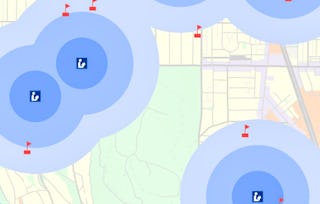
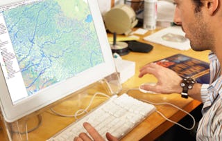
3 Projektbilder
Dozent
1 Kurs1.736 Lernende
von
Was Sie beim Lernen erwartet
Auf Kompetenzen basierendes, praktisches Lernen
Üben Sie die Anwendung neuer Kompetenzen anhand von berufsbezogenen Aufgabenstellungen.
Anleitung durch Experten
Lernen Sie mit vorab von Experten aufgezeichneten Videos in einer einzigartigen aufgeteilten Oberfläche.
Keine Downloads oder Installation erforderlich
Greifen Sie in einem vordefinierten Cloud-Arbeitsbereich auf die Tools und Ressourcen zu.
Nur für Desktop verfügbar
Dieses begleitete Projekt ist für die Bearbeitung an einem Laptop oder Desktop-Computer mit stabiler Internetverbindung konzipiert und nicht für Mobilgeräte.
Warum entscheiden sich Menschen für Coursera für ihre Karriere?

Felipe M.
Lernender seit 2018
„Es ist eine großartige Erfahrung, in meinem eigenen Tempo zu lernen. Ich kann lernen, wenn ich Zeit und Nerven dazu habe.“

Jennifer J.
Lernender seit 2020
„Bei einem spannenden neuen Projekt konnte ich die neuen Kenntnisse und Kompetenzen aus den Kursen direkt bei der Arbeit anwenden.“

Larry W.
Lernender seit 2021
„Wenn mir Kurse zu Themen fehlen, die meine Universität nicht anbietet, ist Coursera mit die beste Alternative.“

Chaitanya A.
„Man lernt nicht nur, um bei der Arbeit besser zu werden. Es geht noch um viel mehr. Bei Coursera kann ich ohne Grenzen lernen.“
Bewertungen von Lernenden
- 5 stars
69,23 %
- 4 stars
23,07 %
- 3 stars
0 %
- 2 stars
0 %
- 1 star
7,69 %
Zeigt 3 von 13 an
KB
Geprüft am 29. Aug. 2024
excellent intro to ArcGis and doing something useful very quickly
Ihnen könnte auch Folgendes gefallen:
 Status: Kostenloser Testzeitraum
University of Toronto
 Status: Kostenloser Testzeitraum
University of Michigan
 Status: Kostenloser Testzeitraum
University of California, Davis
 Status: Kostenloser Testzeitraum
Coursera